Rouge Valley Conservation Centre

To donate to the Rouge Valley Conservation Centre click on the button below:

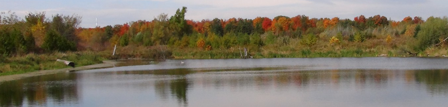
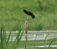
The wonder of local wetlands
What is a Wetland?
A wetland, defined at its simplest, is just what its name describes: land that is wet. To be more specific, it is land that is saturated with enough water for a long enough period that the soils are waterlogged, and standing or slow-flowing water may also be present. As well, the resident flora and fauna are adapted to a wet habitat and lifestyle.
Why are Wetlands Important?
Wetlands were traditionally regarded as areas of wasted land, as they were generally not suitable for industrialized agriculture or good areas on which to construct buildings and other infrastructure. They also tended to be regarded as eyesores, and soggy areas plentiful with annoying mosquitoes and other insects as well as smelly mud. However, wetlands are extremely important to the natural environment as well as to humans, and can also be visually stunning landscapes. Just some of the benefits and services provided by wetlands for humans and the environment include:
• Minimizing the impact of flooding events due to their immense capacity to absorb and store water
• Minimizing the effects of drought by slowly and continuously releasing water to the environment (i.e. through streams or groundwater)
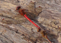
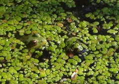
• Biological productivity, meaning they support an abundance of plant and animal life. This not only contributes to biodiversity, but can also provide essentials such as food, medicine, and building materials to humans.
• Recreational opportunities through activities such as bird watching and fishing, as well as valuable educational opportunities. Many wetlands also have great importance to First Nations people in terms of resource and cultural value.
• Improving water quality, wetland plants use and assimilate excess nutrients in the water, and microorganisms feed on and break down harmful pollutants. For this reason, wetlands are known as “nature’s kidneys,” and purposefully using natural or constructed “treatment” wetlands for waste management is becoming a more common practice.
• Reducing erosion by trapping sediments in the roots of plants, which can reduce degradation to plant and wildlife habitat caused by excess sediment
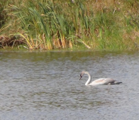
• Providing habitat to rare, migratory, and at-risk species. It is estimated that roughly a third of all threatened or endangered species in North America rely on wetlands as critical habitat.
• Carbon sequestering (especially in peatlands); meaning carbon is stored long-term instead of being released into the atmosphere and exacerbating climate change
Wetland Classification
The Canadian Wetland Classification System defines a hierarchical approach to classify wetlands. This system includes class, form, and type, from broadest to most specific. Wetlands are separated into different classes based on their environment and how they developed. The Canadian Wetland Classification System defines and uses 5 wetland classes.1
1) Bog:
Bogs are a type of peatland, which means they accumulate partially decomposed organic material called peat. Bogs are interesting in that the only sources of water that feeds them are direct precipitation, such as rain, snow, and fog, and are therefore referred to as ombrotrophic. All other classes of wetlands are fed by other sources of water in addition to precipitation. These sources include (but are not limited to) streams and groundwater, which generally contain higher quantities of minerals than precipitation. Therefore, all the other classes of wetlands are referred to as minerotrophic. Bog waters are acidic and tend to be in the 4.0 to 4.8 range on the pH scale, and are low in dissolved minerals. This acidity comes in part from precipitation (which is mildly acidic), but more so from the acid that is created through the decomposition of peat. Bogs usually have a high water table generally at or near the ground’s surface level.
The most typical species to find in a bog are mosses in the genus Sphagnum, commonly known as peat mosses. Other plants that prefer acidic soils, called ericaceous plants, can also be found in bogs, and trees (often black spruce) may or may not be present as well. Due to their acidic conditions, bogs are the least biologically productive of all wetland classes, but often have unique and sensitive species.
Bogs are typically formed of two layers. The thinner surface layer contains the roots of living plants, and since oxygen is present decomposition of dead plants can take place here. However, the deeper layer of a bog consists of waterlogged peat that is very low or completely lacking in oxygen. Without oxygen, full decomposition of organic matter cannot occur, which is why peat accumulates. Any peat that survives total decomposition in the surface layer will eventually make its way down to the deeper layer, where it will be stored. This lower layer can be very thick: on average it has a depth of 3-5 metres, but has been found to be as deep as 10 metres.
Given that they essentially act like huge sponges, bogs provide the essential ecological service of storing and slowly releasing water, which can help in areas prone to flooding. Since their acidic habitat provides a lot of challenges for life, the living things that have adapted to live there are some of the most unique that exist, such as the carnivorous sundew plant.
2) Fen:
Fens are also a type of peatland, however they are minerotrophic instead of ombrotrophjc, meaning they receive water from sources other than just precipitation, and therefore they are richer in dissolved minerals and are less acidic than bogs. Fens commonly have ground and surface water flow, with a water table that experiences fluctuations.
Because of the higher mineral content and lower acidity of the soil, fens are generally able to support a much more diverse community of plants than bogs can. The types of plants that grow in a fen are heavily dependent on the depth of the water table and the water chemistry. In wetter fens, grass and grass-like plants (called graminoids) as well as mosses (bryophytes) tend to dominate, while in drier fens shrubs and trees may be more common. Interestingly, fens can eventually become bogs if the peat layer builds up enough so that the fen is separated from its groundwater supply, and becomes reliant on precipitation only.
Fens are similar to bogs in that they can reduce the risk of flooding by trapping and storing water, and are also hosts to many unique animals and plants. As with bogs, the thick layer of peat that forms in fens contains a very large amount of stored carbon, keeping it out of the atmosphere.
3) Marsh:
Marshes are wetlands with shallow water present that fluctuates over some period of time: daily, seasonally, or annually, due to inundation by slow-moving or standing water. Therefore, marshes can receive their water from a number of sources, including stream flow, precipitation, tides and runoff, and many can also be fed by groundwater. The fluctuation of marsh water levels can be dramatic, and is due to changes in the amount or frequency of input from one of its water sources, or a change in the marsh’s water output capacity. Marshes can be freshwater or marine.
Marshes often have high nutrient levels, and the pH of a marsh is often around neutral. Being high in nutrients and having a neutral pH means that marshes overall have the highest levels of biological productivity of all wetland classes. This allows many different kinds of plants to grow in there habitats, and in turn can support many animal species. The characteristic smelliness of marsh habitat is due to the decomposition that occurs here as a result of its highly productive ecosystem, which produces gases such as methane. The plant communities that grow in marshes are comprised of many different types of aquatic plants, such as graminoids (grasses, sedges, and rushes), as well as water-tolerant shrubs, floating and submerged plants, mosses and algae. A marsh can be divided into zones based on the tolerance of plants to different water depths and the duration that the soil remains wet. Upland plants exist in the outermost (driest) zone of the marsh, and aquatic plants in the innermost (and wettest) zone.
Marshes can be important in times of drought, due to their ability to release water slowly over a long period of time, maintaining the flow of water to streams or recharging groundwater sources. On the flip side of the coin, marshes can also help mitigate the effects of flooding by slowing down the flow and storing excess water. Marshes also provide the ecosystem service of filtering and cleaning water: as water moves through a marsh, pollutants can settle out on the bottom and are broken down by microbes or stored in sediments. Excess nutrients can be used by marsh plants, and resident microorganisms can use many pollutants for food, thereby breaking them down.
4) Swamp:
“Swamp” is a term often used by people when describing any wetland, and often has a negative connotation associated with it. However, for a wetland to be grouped in the swamp class, it must follow specific developmental and environmental criteria just as with the other four classes of wetlands. Like other wetland classes, swamps are important features in the environment, and can often be very picturesque, meaning the negative perception of swamps is quite unfair!
A swamp is a wetland that is dominated by woody plants (i.e. trees and shrubs). While other wetland classes may have trees present, to be classified as a swamp the percent cover of trees in a wetland should be greater than 30%. The soil in swamps is saturated with water during the growing season, and they may also have standing water present at certain times of the year. The soil in swamps can consist of mineral soils as well as peat, with highly decomposed peat being accumulated over time due to the presence of large amounts of woody vegetation.
The different plant communities in swamps can be grouped into one of three very general categories: a thicket swamp (meaning it is dominated by shrubs), a coniferous swamp, or a deciduous swamp. Of course, many swamps may exhibit a mix of these three community types. Often, coniferous swamps will be found in areas of poorer nutrient content (though they can also be found in higher nutrient areas), while deciduous and thicket swamps tend to be in richer nutrient conditions. Shrub swamps often occur in wetter areas, while deciduous swamps occur in drier areas.
Like marshes, swamps are important for minimizing the effects of flooding. Forested swamps near the banks of rivers can help by retaining some of the floodwaters, and may experience high productivity due to the nutrient content of the floodwaters as well. Swamps can also be a valuable source of timber, though responsible resource use is important to ensure the ecological function of the swamp can be sustained over time.
5) Shallow Water:
Shallow water wetlands are a class recognized by the Canadian Wetland Classification System, though not by the province of Ontario. They are defined as a type of transitional habitat between lakes and marshes. Shallow water wetlands generally have standing water year round at fairly stable levels, with some exceptions during periods of drought. To be classified as a shallow water wetland, the wetland should have a standing water level of less than 2 metres depth in the summer, and at least 75% of the total wetland area should be open water. This means they are too deep for emergent vegetation to grow within most of the wetland area, though there may be some floating or submerged plants. Shallow water wetlands are also commonly known as ponds or sloughs.
Like other classes of wetlands, shallow water wetlands can help with maintaining stream and groundwater flow, as well as minimizing the effects of flooding. They can also be nutrient-rich environments, conducive to a biologically productive habitat.
Rouge Park Wetlands
It’s estimated that just 10.6% of the total land cover in Rouge Park consists of wetland, Most of this wetland area is classified as swamp (9.4%), with marsh coming in second (1.3%), and negligible amounts of fen, bog, and shallow water wetlands are also present. Rouge Park is home to natural and constructed wetlands, both of which are important features in the ecological landscape of the park. In terms of the entire Rouge watershed, a complete inventory of all wetlands has not been done, it’s estimated that currently mapped wetlands account for < 1% of all Rouge watershed land.2
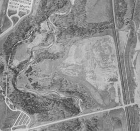
The Beare wetland is located at the top of Beare Road, not far from the Rouge Valley Conservation Centre, and is a great example of successful restoration and wetland construction. The story begins with the Beare landfill, now visible as the very large hill past the end of the road, which was in service from the mid-1960s to mid-1980s. Its garbage was frequently covered by a layer of soil so as to minimize unpleasant smells and animal scavenging. In addition, when the landfill was eventually decommissioned, a cap of soil a few metres thick was placed over the mound of refuse. All that soil, sand and gravel was taken from pits west of the landfill across the train tracks, a process that effectively destroyed the natural habitat of that location for the duration of the landfill’s operation. This area was referred to in the past as the Beare Road Borrow Pits.
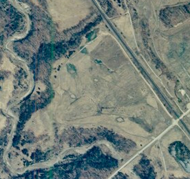
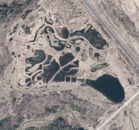
Once the soil pits were no longer being used for landfill purposes, the area was very slow to regenerate on its own. All the topsoil had been taken away, leaving a hard subsoil that was unfit to support many different species of plants and animals. After the site languished for 17 years following the closure of the landfill, the Friends of the Rouge Watershed group decided to try and restore the habitat of the pits. Their first effort was to plant the area with native trees, however this was only minimally successful. It was then suggested by a local naturalist that restoring the area into a wetland complex may be a better fit. Various sizes of wetland ponds were excavated, some deep enough to hold several metres of water year round and others serving as vernal pools, new top soil was brought in, and many volunteers helped to plant the bare soil with native plants. Since its grand opening in 2006, the Beare wetland complex has become home not only to the native plants that were planted there, but also many native wetland animal species that have moved in to this ideal habitat, including some species at risk such as the threatened Blanding’s turtle.3
At the mouth the Rouge River where it empties into Lake Ontario lies a natural wetland complex known as the Rouge River Marshes Wetland Complex. This wetland complex measures 55.7 hectares and falls in both the City of Toronto as well as the Regional Municipality of Durham. It extends from Lake Ontario up to highway 401. The complex is made up of 6 individual wetlands, and is overall classified as 64% marsh habitat and 36% swamp habitat, with 23 different vegetation communities.
This complex is designated as a Provincially Significant Wetland (PSW) by the Ontario Ministry of Natural Resources and Forestry, one of only six within the city of Toronto. Designation as a PSW means that development is prohibited therein, and any alteration causing negative impacts on the PSW is also prohibited on its adjacent lands. The Ontario Wetland Evaluation System (OWES) is the protocol used to evaluate wetlands, and looks at features in biological, social, hydrological, and special features categories. For a wetland to be designated as provincially significant, it must score greater than 600 points in total, or 200+ in either the special features or biological category. The Rouge River complex scored high in the special features category due to the presence of species at risk, such as the Blanding’s turtle and the least bittern. In the 2009 survey report completed by North-South Environmental Inc. for the city of Toronto, the survey found that 69 bird species may use the marsh complex to breed, including several species rare in urban southern Ontario like the black tern. The Rouge River marsh complex was overall found to contain 15 provincially significant animal species, 2 regionally specific plants, and 54 locally significant plant species. This marsh is also considered signification habitat for fish, as fourteen species have been found to use the complex for spawning and nursery areas.4
In addition to ecological value, the wetlands in Rouge Park also have economic value. A study commissioned by the David Suzuki Foundation estimates that wetlands in Rouge Park provide an estimated $9651 per hectare in non-market economic benefits each year. This is the highest non-market value per hectare compared to other land types in the park, such as forests and agricultural crop land. Even given the relatively small land area occupied by wetlands in Rouge Park (approximately 10.6% total land cover, about 414 hectares), the park’s wetlands are estimated to provide 3.99 million dollars in non-market economic benefits per year. Part of this non-market value is the value of ecosystem services, such as the storage of freshwater, carbon storage, waste treatment, food production, and flood control. 2
Restoration and Creation of Wetlands
Since the time of the first European settlers in the area, local wetlands have been destroyed, altered, or over-used for the benefit of humans. Since wetlands were regarded as “wasted” land, they were often drained and/or filled in to become more suitable for agriculture or urban development. Very little original wetland coverage remains in this area: it’s estimated that 70% or more of southern Ontario’s original wetlands are now gone. However, although wetlands are still vulnerable to human disturbances, they are now recognized as essential habitats and conservation/restoration projects are underway in many areas. Given that the landscape surrounding original wetland habitat has also likely undergone drastic changes, restoration does not necessarily mean changing an area so that it looks and acts exactly like the wetland that was there long ago. Instead, restoration often involves creating or modifying a wetland so that it can function well in its current landscape.
In addition to the Beare wetland creation project (described above), another wetland restoration project that occurred in the Rouge Watershed was the Newberry Park Wetland Restoration project in Richmond Hill. This project was carried out by a partnership between the Town of Richmond Hill, Ontario Streams, and the Ontario Ministry of Natural Resources and Forestry.
Newberry Park was a recreational sports park built in the 1980’s on what was originally a headwater swamp of the Rouge River. This park had problems from the beginning due to its location, one of the most notable being excessive groundwater seepage. This seepage was considered a safety concern for sidewalks and rendered the soccer fields and baseball diamonds unusable. After the Town of Richmond Hill decided to stop using the fields, a project to restore those areas of the park to their natural state was proposed.
In addition to the restoration of wetland habitat, the project proposed that fish habitat in Tributary B of the Rouge River (which runs through the park) would also be improved. The original Tributary B had been channelized during the construction of the park and other local urban development, causing degradation to fish habitat. The restoration project proposed to use the groundwater resources to create a new tributary flowing through the park and eventually discharge into Tributary B. Newberry Park also lies within a Provincially Significant Wetland, the Rouge River Headwater Wetland Complex, making the restoration project even more valuable. The restored area now also includes observation areas and interpretive signage to make it a welcoming place for people as well as wetland wildlife. 5
In any restoration or re-creation process, the first step is to figure out how the area originally looked and functioned. This information can be gathered through old survey data, photographs, or even talking to long-time residents of the area. After this, the current state of the area should be assessed to see what kinds of restoration may be possible, and if any species may be harmed or displaced as a result. Goals for the new site should also be considered: for example, will it be an interpretive site, or off-limits to people? The actual restoration process can also be a good chance for public outreach and education; for example, having local residents plant native vegetation in the new wetland. Finally, monitoring and maintenance of the restored/re-created wetland is as essential as the initial restoration process. However these components of most projects are only undertaken to a very limited degree, putting many projects at risk over time. If the wetland is allowed to degrade through the introduction of invasive species or other factors (which is common in the GTA), the entire restoration process may have to be repeated again.
It is important to note that while restoration and re-creation are necessary undertakings in many areas, emphasis should be placed on protecting existing wetland ecosystems, as a restored or re-created wetland rarely compensates completely for the role the original, natural wetland played in the ecosystem.6
Sources:
1. http://www.gret-perg.ulaval.ca/fileadmin/fichiers/fichiersGRET/pdf/Doc_generale/Wetlands.pdf
2. Note: The estimate of 10.6% wetland cover in Rouge Park comes from the David Suzuki foundation report from 2012. This report includes statistics for three different study area sizes: 1) Rouge Park (as delineated in 2011, totalling 3890 ha), 2) the future park including proposed additional federal lands (totalling 5838 ha), and 3) Rouge River plus Petticoat Creek and Duffins Creek watersheds (64 623 ha). The 10.6% and all other associated data comes from the current 2011 Rouge Park. http://www.davidsuzuki.org/publications/downloads/2012/report_Rouge_Natural_Capital_web.pdf
3. http://www.insidetoronto.com/news-story/6157791-stories-from-rouge-park-the-beare-road-landfill-started-as-a-sand-and-gravel-pit-and-is-now-part-of/, http://www.frw.ca/pdf/frw_rgb_web.pdf, http://www.westrouge.org/PDFs/WR_article_24.pdf
4. https://www1.toronto.ca/city_of_toronto/city_planning/home/files/pdf/wetland_report_aug09_small.pdf
5. http://www.ontariostreams.on.ca/PDF/FinalNewberryParkESROct2007.pdf
6. https://www.ontarionature.org/discover/resources/PDFs/misc/wetland_restoration.pdf
Beare area in 1987 before wetland
Beare wetland area in 1999
Beare wetland area now
Written by S. Crowley and D. Lawrie
Photos by D. Lawrie
Kids Programs
Special Events
Donate
About Us
Rouge Valley Conservation Centre © 1995 – 2009 All rights reserved
Rouge Valley Conservation Centre © 1995 – 2017 All rights reserved